Having left Mexico City, we headed first to the town of Amecameca, and from there caught a colectivo van up to Paso de Cortés:
these passengers were all drinking beer at noon, and most of them promptly fell asleep on the ride
At Paso de Cortés, our first good look at the volcano Popocatepetl, Mexico's second highest peak at 5400m or so... unfortunately, it has been closed to climbers since 1994, as it is considered active and dangerous.
our lunch: street food discovered in Amecameca and transported to the mountain. These are like tlacoyos, but instead of black beans they have fava bean fillings. They are covered in green beans, onions, and lots of hot red salsa.
having entered Izta-Popo National Park, we started on our trip to climb Iztacíhuatl in late afternoon, heading for the shelter at La Joyita at 3990m... where our first night featured a mighty hail storm:
this is Izta, our first view of the mountain, the following morning at dawn, in inclement weather.
we attempted to climb that day, but eventually ended up in whiteout conditions... We did, however, have the opportunity to remove some terrible graffiti from some rock overhangs we had stopped to rest under. It seems that this weird cult even makes it to 4500 meters, scarring the mountain scenery with its propaganda...
Before:
During:
After:
we had some nice views over the valley as we descended out of the whiteout above.
The following morning, after another night of rain, hail, and some snow, we started out at 4 AM under clear skies. First we had great views of our constellation overhead (Sagittarius, just next to Scorpion), and as we headed up we were treated to this view at dawn:
The peaks seen here are our next projects: La Malinche is seen in the midground on the left, and Orizaba, Mexico's highest, is seen on the right in the distance, a perfect cone.
The valley of Lake Texcoco at dawn, now completely swallowed up by Mexico City, either the largest or second-largest city in the world, depending on who you talk to (Tokyo the other). Ironically enough, we were two of only four people (the other two being French guys) on the mountain for this climb, with 25 milllion people only 50 km away.
the refuge at 4800m, cold and forlorn...
the refuge at 4800m, cold and forlorn...
Jeff coming up icy and rocky slopes, Popo in the background
Another shot of the gorgeous Popo, mid-morning
Another shot of the gorgeous Popo, mid-morning
the route to the summit featured a rollercoaster set of ups and downs, all above 5000m, about 6 in all. Very taxing, but incredibly beautiful.
At the summit (El Pecho), about 5230m, in bright and sunny conditions
The park service leads a coalition of groups concerned with hydrological issues in this national park. Here we see a pine sapling, part of an immense reforestation program they are undertaking.
This was to be our number one campsite of the whole trip so far, for scenic beauty. We are stealth camped near Paso de Cortés:
packing out the next morning... Izta beautiful and crisp in the background...
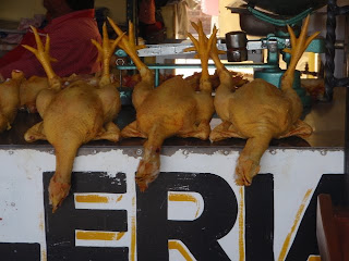
macabre chickens spotted in Cholula, on the way to Puebla...
amazing street food in Cholula. These are shrimp molotes, which are fried corn tortillas stuffed with baby shrimp and smothered with spicy green salsa. 15 pesos each, or about $1.25.
La Malinche as seen from downtown Puebla at the CAPU bus station
heading up La Malinche, we were followed from the start of the climb by three very adventurous dogs
like a repeat of Izta, our arrival was greeted by a late afternoon hail storm.
severe erosion on the slopes of La Malinche just above treeline
in the evening, we attempted to climb up aways, but were turned around by whiteout conditions and lightning and thunder on the exposed ridge.
The following morning at dawn we got off to another attempt, this time under clear skies. The dogs were still with us, and by this point we had named them. Here are pictured Blackie and Number Three. (Number Three, uninvited but in the end a good guest, had slept under Jeff's tarp the previous night during the storms).
at the summit of La Malinche, the dogs are as elated, contemplative, and calm as we are:
some snow and rock scrambling started the descent...
...which had us high above the valley floor below...
La Malinche from treeline in early morning, fresh with its coat of new snow...
descent through warming pine forest
gorditas found after descending... potatoes, onions, green and red salsa, and absolutely delicious.
This foul scene depicts Jeff's dirty mountain-climbing socks in a Puebla hotel room
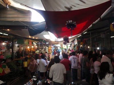
...scenes from Mercado Hidalgo in Puebla...
briefly reunited with Anna Kortschak for some street food gorditas in downtown Puebla. After separating in Zacatecas in February, Anna rode solo to Puebla, and at this time was volunteering as a photographer for a street kids non-profit organization in Puebla.
From Puebla we headed out on our third and final climbing adventure: Pico de Orizaba. Here is a street scene in Tlachichuca, the jumpoff town for the climb...
...Orizaba gleaming and beckoning in the distance...
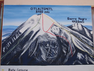
a rough sketch of the route we were to take, seen at Citlaltepetl climbers' hostel in Tlachichuca, where we rented ice axes, double plastic boots, crampons, and thick mittens.
Jeff getting underway with a loaded pack
First we hitchhiked partways to the base of the climb, here in the back of a truck used to haul hay...
shepherd herding sheep at dusk near Hidalgo
the next morning, heading up to the shelter at 4000m, we passed through some cool pine woods
...coming above treeline into bright sunshine
now much closer to the peak, the shelter is barely visible lower left
late afternoon nap at 13,300 feet
views from a dusk walkabout near the shelter
Jason checks out the scene and ponders the climb ahead
We got off to a 1:30 AM start, first moving up through scree...
...then snow...
...and soon we were gearing up for the glacier...
dawn high on the slopes of Orizaba:
Jason stops for a breather just before sunrise
Jeff bedazzled by Orizaba's immense shadow at sunrise
we angled up steep, cruddy ice slopes for thousands of feet
near the summit in early morning
the summit crater
Jason shivering and exhilirated at the summit, 5700m, which is the third-highest peak in North America after Denali and Mt. Logan. However, this is a FAR easier climb than either of those two.
descent through pine woodlands
water catchment trenches dug into Orizaba's middle slopes...
...to retain water and replenish groundwater supplies...
the tiny, poor village of Hidalgo, dominated over by Orizaba...
fava beans planted right on the mountain's slopes
blissed out on beet/carrot smoothies we found in Tlachichuca. 10 pesos a glass, or 80 cents.
the source of the magic beet smoothies
street food scene in Tlachichuca
these are death shrine images found in Puebla's Facoya Market.
Astonishing, La Santa Muerte...
Jeff getting ready to chomp a huge quesadilla (minus cheese) bought in Puebla. These are loaded with mushrooms and veggies and the obligatory hot sauce.
...a comedy troupe performed in Puebla's Zócalo as part of a free festival...
using Mexico's famous Lucha Libre (wrestling) as a theme......our climbing adventures completed, we headed back towards Zipolite to recollect our bikes. Here we are in Oaxaca's second class bus terminal in the middle of the night, with some curious neighbors:
...Now in Pochutla, near Zipolite, we were thrilled to find bean tamales, 3 for 10 pesos... which Jason wasted no time in consuming...
also in Pochutla, the Mexican Post delivers on two wheels, non-motorized.
back in Zipolite, we took advantage of these hammocks for several days
Jason does some bike prep work (broken spoke replacement) in advance of our upcoming movements, waves crashing in the distance
This was our spot in Zipolite, La Posada de Kiko, where the friendly Italian manager Davide had allowed us to leave our bicycles during this recent side trip.
we found curried vegetables at Shambhala, up on the hill

a vendor on the beach at Zipolite
From Mazunte, we hiked out to Punta Cometa:

...scrambling up the sea cliffs...

Jeff soaking it up late afternoon at Playa Cometa near Mazunte
Playa Cometa, unspoiled and spectacular
Mazunte beach in the distance
We visited the Sea Turtle Conservation Center in Mazunte while still in the area... and were impressed by the displays and the conservation focus...
pictured here are three of Mexico's seven species of sea turtles, most of any country in the world:
not a sea turtle but impressive nonetheless
out to dinner in Zipolite
partying at La Posada de Kiko with an international group of French, Mexican, American, Argentinian and Czech, during a version of spin the bottle
full moon above Zipolite beach


8 comments:
Great to see the mountain pics finally! Your ascent of Izta really does make it look like a completely different mountain to mine.
Absolutely awesome post. Wow. Thanks for sharing it with us.
-Randy and Nancy (from Palisade, Colorado)
Hey Jason,
Thanks for the new posts! I've been checking in on the blog and I'm in awe of the photos and experiences you document. Ridiculously amazing! Hope you are enjoying. May the road rise to meet you! Shana McNamee
Super chido viaje hermanos Volks!!! you know for sure how to live and enjoy life!!! it has been great to get to know you in mexican land, nuestro México tan lindo y querido los abraza y les da la bienvenida y tambien la despedida que esperamos que no sea para siempre... all the best!!! thank you very much for sharing. See you in Toluca??? Besos. Diana (we met on your way to Tonina)
I did not understan really well this thing about the ID...
sick dawg! way to rally!
vaya con Dios:::
that's some sweet adventuring you guys are doing. I hope to be doing the same pretty soon. Ho wdid you guys get your info on the climbs, route maps etc?
You have some classic pictures, i like the one with the dogs at the summit, that must have been surreal.
Good luck for future adventures, and keep up the great documentation.
Volk, great to see your getting on well! Been too long. Safe travels and hit me up when you get back state side. Newman
Post a Comment