Once in Quito we got familiar with the truly important things, such as one-dollar smoothies and all-natural carrot-alfalfa juices:

juice bar in the old part of Quito

... some scenes from the very atmospheric historic center of Quito...


Interestingly enough, like the rest of Ecuador, Quito has undergone some serious changes in recent years. In 1997 for example, when Jeff was here for a month, the old town was nearly off-limits to tourists, with tales of bag-snatching and violent robbery and evil taxi drivers abounding, as well as the streets being full of people selling everything under the sun. Now the streets are clean, orderly, and the talk of crime has nearly disappeared - its hard enough to get your guitar out on the street without being dismissed by three policemen inside of two minutes. And the streets are full of tourists, both Ecuadoreans and foreigners.

One of the best parts about Quito: cheap vegetarian lunches all over the place, and the consumers are Quiteños, not foreigners. For about $2, you can get a pretty full lunch menu, with soup, main dish, juice, and dessert.

This was our favorite amongst Quito's vegetarian eateries: Govinda's. Excellent ambience, generous servings of food:

Govinda's lunch menu costs $1.80. A dream for hungry cyclists.

While playing in the Plaza del Teatro in the historic part of Quito (the only place the police would allow us to play!), we had several enthusiastic folks get involved in the entertainment. The one seen above sang four songs with us (música bomba), and had most of the crowd singing, too. To watch a short video, in which Craig joins in, see the following YouTube link:

later that same afternoon, with Jason and Sonja now, we had another big crowd, and another visitor on guitar

in Otavalo, grilled plantains and corn

this is to be Jason Dylan's album picture (Otavalo)

dried foods at Otavalo market

This was to be a day of glory. We learned that on Sundays it is possible to perform street entertainment in a certain atmospheric alleyway (Garcia Moreno/ Eugenio Espejo) of the old city. Just adjacent to Plaza Grande. So we played for four hours, and we made a little money, too: $165. In Ecuador.

We were also interviewed for Ecuadorean television while playing a song or two and describing our adventures.

these girls were our biggest fans, sitting for a long time and singing along. Their favorite song was "Monkey and the Engineer".

Having left Quito and headed to the fire station at Machachi, we ran into Alan and Erin, an American couple going south on tandem since northern Canada. This was our second run-in with them, as we had stayed in the Cali casa de ciclistas in Colombia at the same time, about 6 weeks earlier.

at this time they were travelling with Fernando, a Colombian cyclist

At the fire station, we found a scale, and just for kicks decided to weigh our bikes, since people have been asking us since Alaska how much our bikes weigh. Jason's weighed 96 pounds, all loaded up. Jeff's: 109. Alan and Erin's: 190 (tandem). Fernando's: 122. (this is mindboggling since Fernando weighs only 138 pounds! Turns out he is carrying all kinds of crazy stuff, like snorkeling fins and mask, and a shelfload of books, among other things).

This photo clearly shows the twin peaks of the Illinizas, 5000 meter-plus volcanoes found south of Quito. Our plan is to climb Illiniza Norte, the less-technical of the two. We also have a larger plan in mind: we are to acclimitize for a climb of Chimborazo, Ecuador's highest volcano, the following week.
Having left our bikes at Llovizna, a friendly hostal in El Chaupi, we started up the lower slopes of Illinizas:


our campsite at La Virgen at 3900 m. It stormed and rained on us during the night, giving us doubts as to whether we would be able to climb, but the scene in predawn conditions was very favorable:

the evening's weather had left a gorgeous cap of fresh snow on the two peaks

just before dawn, that is Cotopaxi in the midground, at 5897m, the second-highest volcano in Ecuador

the refuge at 4800 m near the saddle between the two Illinizas

another glimpse of Cotopaxi, with 5758m Antisana (Ecuador's 4th-highest) in the back left

about to start up towards the peak of Illiniza Norte, sporting our new construction-worker rock-protection helmets

this is Jason coming slowly up steep slopes, with gleaming Illiniza Sur (5248m) as the backdrop

this was a really fun climb, and we were the only people on the mountain

ice crystals near the summit of Illiniza Norte

if you look closely you will see Jason working his way along a ledge, center-right of photo; this area is called El Paso de la Muerte (the pass of death), which sounds worse than it is.

Popping up above the clouds is none other than Chimborazo, at 6310m, seen to the south.

on the summit of Illiniza Norte: 5,126 m (16,818 ft)

Jeff takes in the scene among the cliffs that form the summit of Illiniza Norte
Jason says he wants to be the first person to climb all the world's 5000m peaks in Crocs:


fog rolled in as we started down

this was a nice descent, with broad views and great vegetation in the high páramo:


these amazing plants all seen around 4500m elevation on the slopes of Illiniza

Back down from Illiniza, we headed out of El Chaupi on a series of high lonesome dirt roads passing along the skirt of the twin volcanoes:


this kind of ride doesn't happen everyday, following jeep trails through high páramo and flanked by 16,000-foot-plus volcanoes

Ecuadorean traffic jam

there was a single pig following this circus as well

our first good view of Tungurahua (5016m, 16,456ft), our next acclimitization peak for Chimborazo.

we stopped first in Ambato, at a casa de ciclistas whose protagonist has been a national MTB champion (cross-country) in Ecuador in past years. These are just a few of the countless trophies displayed in the house:


This is Leo Marujón at the Ambato casa de ciclistas (BikeHouse). Campeón!

his young daughter (after playing with Mom's makeup kit)

working it, barefoot

we celebrated two years of life on the road in Baños with a couple of Pilseners

we weren't gonna let this little sign stop our forward momentum. Technically, Tungurahua is a very active volcano which has been in nearly-constant eruption for 12 years, so much so that there are local nightly tours from Baños to see the lava explosions. However, we did a little research, and found that daily seismic events had reduced to less than 10, whereas they were once more than 50 per day. So we decided to go for it.

Tree tomato (tomate de árbol) seen on the lower slopes of Tungurahua


fertile volcanic lands

a common scene in the Andes: fog slowly eating away your gorgeous views

here we are near the refuge at 3800m, this is a view towards the summit of Tungurahua. Tungurahua may not be technical, may not even have ice, but it is one of the most physically-intense climbs in Ecuador. Starting at 1800m elevation in Baños, you climb 3200m to the summit! which is around 10,500 feet vertical gain. All of which is great training for Chimborazo, anyway.

we camped next to this ruined refuge, into which burning bombs of volcanic rock had fallen countless times over the past 12 years

heading up towards the summit in dubious weather, this was to be the best view of the day. High winds turned Jason around, Jeff pushed on...

trudging up very steep volcanic sand slopes in the mist

Jeff made it up to the snowline around 5000m, but turned around just short of the summit due to dangerous crosswinds blowing over 60mph, amidst whiteout conditions.

cool vegetation in the high páramo

...cloud forest on the upper slopes of Tungurahua...


heading back down the mountain, the trail started in cool cloud forest, but soon devolved into a bed of thick mud:


Baños seen from the lower slopes of Tungurahua. That evening we had a nice long soak in the hot springs near the waterfall in town.

what would a bus ride be in Ecuador without the Baby Jesus?

back in Ambato, Leo cleaned and maintenanced Jeff's suspension fork, which had gone 27,000km without any attention

getting ready to leave BikeHouse, we took this banner with us to shoot a photo on top of Chimborazo.

more evidence of CHANGE in Ecuador. The national road-building program is on speed, building new highways all the time and widening and refurbishing old ones. Some of this borders on the absurd, such as the 8-lane monster between the metropolises of Ibarra and Otavalo. Here they are planning a widening to 4 lanes between Ambato and Riobamba for 2012-13. The propaganda for these projects is ubiquitous in Ecuador.

More evidence of highway widening. The unfortunate thing is, with all of this highway action, that there is no environmental-control improvements. Ecuador has had the dirtiest air of any country we have visited on this trip; as a cyclist you are duly aware of this. If you happen upon the PanAmerican highway, or any well-travelled road in Ecuador, inevitably you will end up in a lingering cloud of black diesel particulate belched out by any number of trucks, pickups, buses, construction vehicles, etc.. In some areas, this black cloud hovers over the highway perpetually.

Sign reads: Saturday, Holy Day. Respect it. Have Jews for Jesus invaded Ecuador?

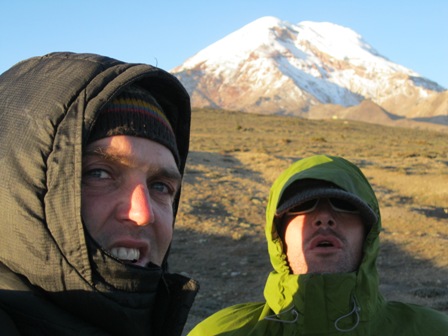
Now in Riobamba, Chimborazo rises above the rooftops

we were hosted in Riobamba by Norma, who picked us off the street corner at dusk and took us home. In Riobamba we rented moutaineering gear from Veloz Coronado Expeditions (esquina Chile y Francia), a very friendly family-run business. The gear was in great shape: double plastic boots, crampons, ice axes, mittens, glacier goggles added up to about $12/day.

now we are starting up Chimborazo for real. This is sunset on the 6310m peak, seen from the park entrance on the Riobamba-Guaranda road.
high winds assailed us on the initial part of the climb to the lower refuge, at 4800m. We spent the first night at the lower refuge.

... this whole area is a national wildlife refuge for vicuñas, which were reintroduced from Chilean populations in 1980...

vicuñas are cousins to llamas
We spent the whole day and half the night at the upper refuge at 5000m, acclimating and relaxing before the climb:


the upper refuge

Jason sports a FUBU jacket provided by Leo in Ambato, bringing back fond memories of Wiggers

... favorable weather at sunset time...

We started our climb at 1:30 AM, deeming that to be sufficient to arrive at the summit at sunrise. However, due to very low snow/ice levels on the mountain, the trail proved to be laced with rocks, making for very slow going, and uncomfortable progress (wearing crampons on rocks is hideous). However, because of ubiquitous black ice conditions, we had to keep our crampons on. We got lost below El Castillo in the middle of the night, not sure of the route and the climbers ahead of us having left no tracks. Golf ball size rocks were falling continuously from up above in the darkness, occasionally pelting us. We refound the route, but at 4AM, still not out of the Castillo area, in very high winds, and still at least 4-5 hours from the summit, we decided to turn back for the refuge and try again the following night.

a daytime shot of El Castillo (left of the glacier). In good climbing conditions, snow and ice cover most of this whole exposed section, and make for easier going.

Unfortunately, we were denied a second shot at the summit, as mist and fog rolled in late afternoon the following day. We decided to return to Riobamba. Chimborazo will have to wait for another day...

... evidence of disaster on the mountain. These gravestones mark the deaths of dozens of climbers on Chimborazo over the years...