Not to disappoint, the route south from San Ignacio through what is called the Northern Highlands of Peru continued the dramatic scenery, low-traffic, village-and-small-town, dirt surface adventure that we have been on since Vilcabamba, Ecuador. Every kilometer that we advance into Peru the country becomes more mystical, more gigantic, more baffling, and more enchanting. (Much of our inspiration and information for this route comes from www.hobobiker.com, an excellent source of info, including routes, distances, and elevations, for cyclists in the Americas.)

Before heading out of San Ignacio we got in rehearsal time for some bluegrass songs. Craig works on his mandolin skills.

...excellent graded dirt road out of San Ignacio...


this turned to pavement after a bit, but with no traffic the riding was highly enjoyable

rice fields are all over this region

in Tamborada we found fresh local soy milk being sold at ridiculously low prices in the street. Apparently soy is grown along the berms in the rice fields. We drank about 3 glasses each before you could blink.

the dark side of Tamborada was the plague of mosquitoes we encountered, worst since Yucatán Peninsula.. These are Craig's feet displaying about 200 bites endured while spending the night here.

dusk view from Tamborada

vibrant green of the ubiquitious rice

...curious kids in Bella Vista...


bizarre desert landscape featuring irrigated rice and even a few palms

cactus growing only a few meters away

... this was an unforgiving hot dry stretch...

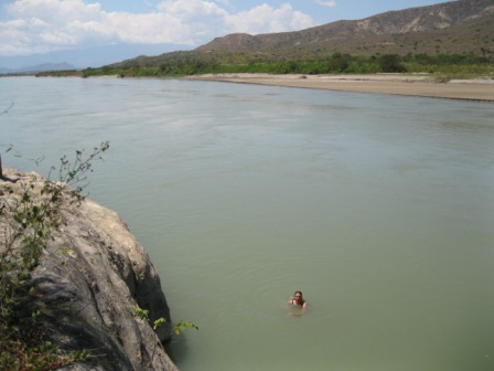
Sonia swimming in the Rio Marañon after finding out that we were lost (while looking for a boat crossing) and had to return to Bella Vista

...eventually we found the boat crossing, and loaded our bikes...


... now in Bagua Grande, these photos document what can only be described as "Peruvian construction techniques", which include a mad retrofit labyrinth of cutoffs and weird angles...

...baling wire holding everything together...

... and ill-fitting planks secured at untrue angles with plenty of awkward spaces between

leaving Bagua Grande we followed this fun road south


our campsite in a great canyon next to a river

...the following morning we started to climb up spectacular mild-graded canyons...


... a run-in first with two Argentinian cyclists, and then two British cyclists, all going north, and a great source of information for us...


more great canyon riding, up the Utcubamba River valley

these construction bricks also deserve special attention for their particular geometry, seen at the Chachapollas/Leymebamba turnoff

back on dirt and loving it
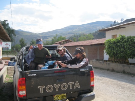
at El Tingo we secured a ride up to the ruins of Kuelap in the back of this pickup truck

this is the road up to Kuelap, over 35km long. Truth be told, the ride was terrifying in the back of a pickup truck (sheer vertical drops into a several thousand foot canyon on a narrow dirt road with no guardrails, where drivers alert other drivers by beeping their horn before turning a steep curve, as in all of Peru) and we would have felt much safer on our bikes.
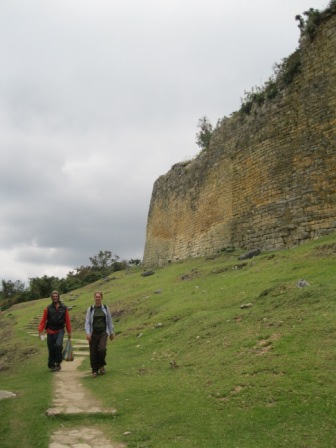
Kuelap, one of the largest archaeological sites in South America, is the most prominent site of the Chachapoyas culture, and dates back to the 6th century A.D.

... llamas on the grounds of Kuelap...


contemplating the views from the top

family portrait of the family who gave us a ride up... they are from Cajamarca

pre-Incan stonework: massive walls which max out at 19m high (over 60 feet high)

cloud forest features amid the ruins

cool architectural details on some of the walls

Kuelap, at over 3000m elevation (nearly 10000ft), is set amongst spectacular scenery. It is just one of many archaeological sites in this little-known part of Peru.

this structure (El Tintero), an inverted cone, defies gravity and the test of time

the ingenious entrance to Kuelap, which made it very difficult for invading armies to break in, since they had to pass nearly single file and were easily fought back.

local girl at Kuelap

flowering cactus seen on the hike back down to El Tingo

heading towards Leymebamba now, a great stretch following the river

gathering supplies and answering questions from kids


drying corn and beans outside Leymebamba


...Leymebamba... small town in the middle of nowhere. We had fried trout here, a delicious Peruvian dish found all over the highlands.


climbing up out of Leymebamba, this climb went to 3600m (12000ft)

and then came the fun part... a 60km, all-dirt, low-traffic, 2700m (9000ft)!!!! descent down to the Rio Marañon. This has been voted the BEST DESCENT of the whole trip. It will be hard to top.

...flying past immense scenery...

... down, down, down, the road dynamited out of the canyon walls in many places

... near the bottom, elevation 900m (3000ft), hot and dry. We found fresh local mangoes in Balsas, thankfully.

now starting up the other side of the canyon. This would be a 45km, 2200m (7000ft) climb back up!!!

the grade was soft, at least, and the scenery unbelievable

... this lower part, insufferably hot, featured some desert forms...


getting close to the top

in Celendín, a welcome break from riding (climbing, that is)

back on the road again, still dirt, there was a 50km climb! between Celendín and Cajamarca. For adventure, scenery, spontaneity, and pure fun Peru has emerged as our favorite country yet.

Craig entertains local kids

campesino house near Cajamarca
(photos this post courtesy Craig Caparatta)


1 comment:
Great your fotos.... But I'd like to have my sister back home, it's too long time without her! Enjoy your trip, all the best from Switzerland, Manuela
Post a Comment